Cities and countries are systems of tremendous, ever-evolving complexity globally, making Geographic Information Science and Technology (GIS) invaluable to professionals.
“A framework of gathering, organizing, communicating and understanding the science of our world”
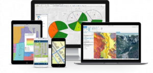
Millions of organizations in every field use GIS to make maps that communicate, perform, and share information. As one can assume, GIS maps are easily shared and embedded in apps, accessibility by virtually everyone, and have a geographical component including imagery, features, and base maps linked to spreadsheets and tables.
The apps which you use daily, provide user experience for getting work done and bringing GIS to life. GIS apps are on your mobile phones, tablets, in web browsers, and on desktops.

When it all started:
In 1854, spatial analysis began when cholera hit the city of London, England, and no one knew how the disease started. British physician John Snow began mapping outbreak locations, locating roads, property boundaries, and water lines.
When he added these features to a map, something interesting happened. He notices Cholera was commonly found along one of the water lines. This process mapping connected geography and public health safety. Not only this event marked as the beginning of spatial analysis but also marked a start to epidemiology, the study of the spread of disease.
It actually wasn’t until 1968 when GIS evolved into using computers. Roger Tomlinson first coined the term ‘Geographic Information System’ in his paper ‘A Geographic Information System for Regional Planning.’ GIS indeed became a computer-based tool for storing map data. In 2014, Roger Tomlison passed away and will always be remembered as the ‘father of GIS.’
The importance of GIS Data:
Geographic Information System (GIS) has various industrial applications, and technological advancements have enhanced GIS Data. It is a powerful decision-making tool for any business or industry as it allows in analyzing environmental, demographic, and topographic data. Data intelligence is collaborated from GIS applications helping in many sectors.
Creating interactive queries, analyzing spatial information, editing data maps are sometimes referred to as geographic information science. In today’s world, GIS is attached to many operations related to engineering, planning, management, transport, insurance, telecommunications, etc. Location intelligence applications are a foundation of many location-enabled services that rely on visualization and analysis.
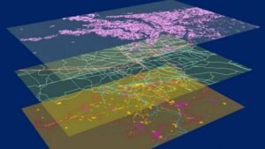
Locations or extents in Earth space-time are recorded as dates/ times of occurrence – x, y, and z coordinates representing latitude and longitude with elevation. GIS nowadays is used in various digitized data creation methods like to transfer hard copy or survey plan into a digital medium through the use of CAD programs and geo-referencing.
How does GIS Technology work?
I know it’s complicated to visualize the locations of latitudes and longitude coordinates from a spreadsheet. In fact, imagining someone physically visualizing and referencing is impossible.
So here comes the best part, as everyone knows that maps make geographic information easier, all you need is a Hardware – GIS workstation and a Software- ArcGIS, QGIS, GRASS GIS, SuperGIS, etc.
For example, you need to find out how much forest is in a city boundary or study area? So the answer is – run a clip on land cover classification, sum of the field of forest grid cells appears.
Before GIS, cartographers mapped out the land using paper maps, and there’s nothing painful than drawing bu-hand thousands of features on paper maps. But this is what it used to be, and since then, we’ve seen a gradual shift away from paper maps.

How does GIS capture real-world features?
GIS is stored as rasters (grids) and vectors. Rasters look pixellated due to a square gridded look. They store data in rows and columns (grid) that are classified as discrete and continuous.
Continuous rasters – grid cells with gradual changing data like digital elevation models (DEM) and temperature data.
Discrete rasters – have distinct themes or categories like the land cover and have separate classes with clear boundaries.
Vectors – Points, lines, and polygons that are generally smooth, rounded features like cities, fire hydrants, contours, roads, railways, and administrative boundaries.
Ways in which GIS Data is used in real-world:
- Mapping: It is used in providing a visual interpretation of data. Google Mapps is an incredible example of a web-based GIS mapping that people use for everyday navigation purposes.
- Telecommunication: Organizations incorporating geographic data into complex network design, optimization, planning, and maintenance activities. A better enhancement of customer relationship management and location can be seen.
- Urban Planning: GIS data helps to identify urban growth and direction of expansion. A user gains a detailed perspective on land infrastructure, new sites for development. It allows planners to understand the needs of densely populated areas to examine smaller towns and informal settlements.
- Transportation Planning: Used for managing transportation issues, accident locations. Planning of new roads, rail routes can also be provided.
- Environmental Impact Analysis: Data gathered is vital for conserving natural resources and protecting the environment. Many human activities have produced adverse ecological effects, including construction, operation of highways, railroads, pipelines, airports, radioactive waste disposal, and more – through the GIS Data; the characteristics can be found out. The data will help in reducing the human effects on the land, which causes environmental degradation.
- Disaster Management and Mitigation: Efficient GIS systems protect the environment and are developed to assist risk and disaster management.
- Flood damage estimation: GIS data is used to map flood risk areas that can be used to relief efforts.
- Natural Resources Management: Forests can be adequately maintained and managed. It will be especially crucial for the allocation and geographic distribution of water.
- Surveying: GIS provides information about land that is used during land surveying to determine the vastness of land and nature of the soil and its soil structure.
- Energy use tracking and Planning: It is used to track the usage of power and other sources of energy to ascertain how much power or energy is needed to satisfy the requirements of a given city or state.
- Regional planning: GIS can also provide essential data that is used in cases where different regions need to be put under different uses.
- Agriculture planning: GIS plays a significant role in agricultural planning that is used to provide information that can be used to plan what crops need to be grown in areas of farm depending on the soil structure and soil composition.
- Geology: GIS is used to analyze soil, soil structure, assess seismic information, and create 3D displays of geographic features. It is also used to analyze rock characteristics and identify the best location for different functions.
- Irrigation Water Management: Availability of water directly affects crop production in a given region. GIS data can identify significant crops and determine the yield.
- Fire equipment response analysis: GIS is used to evaluate street networks from a firehouse that is useful in evaluating the best location for a new firehouse or in determining how well the fire services cover a particular area.
In short, GIS data has a profound impact and use on business and industry, as well as on the general public.

Some common applications for GIS include:
- Review and analysis of plants for development.
- Checks on regulatory compliance.
- Review of environmental impact.
- Preservation of historical site.
- Regional planning beyond the borders of a city or town.
- Mapping the delivery of utilities and planning for service interruptions.
80% of Data is Geographic, Environmentalists being the heaviest users. Agriculture maps are used for precise farming and forestry, tracking deforestation and forest inventory. Military and defense are also heavy GIS users pertaining to location intelligence, logistics management, and spy satellites.
Every day, GIS makes an impact on your life, and you might not even realize it. For example, your car uses GPS navigation, and your job may depend on really accurate weather predictions. Overall, GIS helps us in analyzing the world because it understands geography better.
GIS is being applied in virtually every field of human endeavor, from helping businesses identify new customers to enabling out responses to natural disasters. Over 400,000 story maps were shared publicly in 2017 across virtually every discipline straightforwardly delivering critical messages and results to understand.
Everything is located and happens somewhere in Earth space. Everything that is located on the span area can be described in detail, and every change can be reflexed — allowing us to use every smallest possible detail from natural resources to human activities. You are a click away and BINGO! GIS is making our environment and surroundings understandable and easy to track.
To know more about Architecture Technology, Stay Tuned. Till then, you can visit the Security Awareness Section for day-to-day cyberattacks and how to prevent them.
Previous Coverage:


